The 2026-2027 El Niño episode continues to intensify and has already been classified as a very strong phenomenon, popularly known as a 'super Niño'. Sea surface temperature anomalies in the equatorial Pacific exceed 3 °C, with forecasts pointing to further intensification in the coming weeks. According to Toni Barrera, climate change technician at the Meteorological Service of Catalonia (Meteocat), despite the phenomenon's intensity at its 'ground zero', there are still no attribution studies for its effects in Catalonia. "We cannot yet know if it could translate into heavy rainfall, drought, or minor effects here; we will need to monitor it through tools like seasonal meteorological models, although their skill is limited in our area," explains the expert.
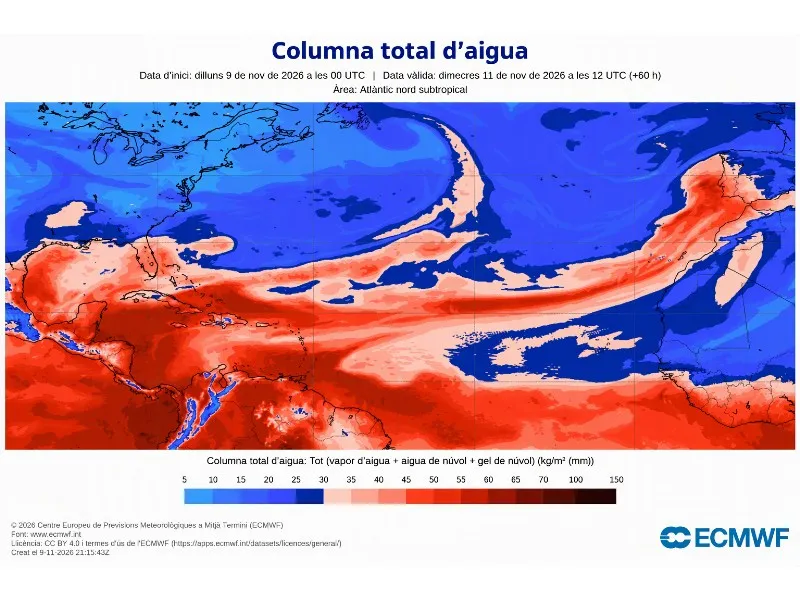
In this context, Meteocat has identified two relevant atmospheric novelties that could be compatible with the onset of El Niño's teleconnections towards Europe and the Iberian Peninsula. The first is the weakening of the polar vortex, and the second is the arrival of an atmospheric river originating from tropical latitudes, associated with storm Charles. Vicent Altava, research and modeling technician at Meteocat, points out that these signals "coincide with two of the physical mechanisms through which an intense El Niño episode can end up influencing the atmospheric circulation of the North Atlantic and, indirectly, the weather in Catalonia," although it is still "not possible to establish that they are a direct consequence of the phenomenon".
The weakening of the polar vortex could favor the propagation of planetary atmospheric waves towards the stratosphere, modifying it and, under certain circumstances, favoring a sudden stratospheric warming (SSW). If these changes propagate to the lower layers, they could alter the general westerly circulation in the Northern Hemisphere and the atmospheric patterns of the North Atlantic, with possible repercussions on the NAO (North Atlantic Oscillation). On the other hand, the arrival of an atmospheric river, a structure that transports large amounts of water vapor from tropical zones, could indicate a strengthening of the subtropical jet stream, another mechanism by which El Niño can generate planetary-scale alterations.
El Niño is a natural climate phenomenon that causes an anomalous warming of the surface waters of the equatorial Pacific. Very strong episodes, like the current one with anomalies exceeding 3 °C, have direct effects in tropical regions. In Europe and Catalonia, the influence is indirect and delayed, through atmospheric teleconnections. "It cannot be assumed that the exceptional intensity of El Niño will necessarily lead to an exceptional impact in Catalonia as well," warn scientists, as the climate system's response is not linear and depends on multiple regional factors such as orography or atmospheric blocking situations.
The possible repercussions on European atmospheric circulation tend to manifest during the winter and spring months. The evolution of the NAO will be key, although the effects on Catalonia do not have a predetermined response, with past El Niño episodes coinciding with situations of both abundant rainfall and drought. Furthermore, the current episode must be interpreted in the context of global warming, which already leads to rising temperatures and a greater frequency of extreme climate events and droughts in Catalonia, regardless of El Niño's presence.